


Startups
How WhereIsMyTransport is Transforming Travel in Middle and Low-Income Cities
Billions of people in emerging market cities rely everyday on a sprawling blend of formal and informal transport networks that are utterly opaque to their governments. But WhereIsMyTransport is bringing data visibility to them for the first time. Lucy Ingham learns more from CEO Devin de Vries

In middle and low-income cities across the world, millions of people make daily commutes that see them relying on a vast mesh of formal and informal transport networks.
These informal transport networks have considerable benefits: they augment government-provided services, rapidly scale and adjust based on demand and help many get to work each day.
But they present a problem: there is no cohesive data on city networks that can be used to plan routes or respond to delays, which is where startup WhereIsMyTransport comes in.
“We founded WhereIsMyTransport in London in 2015 to tackle the stressful experience of being reliant on public transport in the majority world,” Devin de Vries, CEO of WhereIsMyTransport, tells Verdict.
“Markets where billions rely daily on the mix of formal and informal services – the informal services provided by tens of thousands of independent and unscheduled vehicles operating fixed and semi-fixed routes.”
The travellers on these routes often face commutes that would seem utterly punishing by even the most severe standards in high-income countries.
“Minimum wage-earners often end up spending as much as 30% of their incomes on transport, but with painful commutes – up to five hours a day between trips to and from work,” he says.
“Saving only five minutes caused by uncertainty in the top 30 majority world cities would account for 1.5 billion minutes per day. Our data and technology will be a part of making this time saving possible.”

Devin de Vries, CEO, WhereIsMyTransport
Turning informal transport networks into visible data
WhereIsMyTransport may have a worthy goal, but those unfamiliar with the company are likely to raise two issues, the first of which is the assumption that as the world develops, informal transport networks are on their way out. But according to de Vries, this simply isn’t the case.
“Informal public transport will become more and more important into the future,” he says.
“Informal networks, plus a bit of well-timed information, can do much of the work to move a city and it’s within reach today.”
The notion that getting consistently reliable data on informal transport networks is achievable is likely to be the other key concern for many, particularly those used to working with APIs to extract data from established sources. But WhereIsMyTransport is overcoming this lack of readily available data by collecting its own through thorough, on-the-ground efforts.
“In-field data collection is the only way to objectively confirm and collect complete data on public transport operations in emerging market megacities, where the urban environment is volatile, informal transport dominates, and there is little or no information at all on operations,” says de Vries.
“Every data collection project includes research with local communities to build a clear picture of the real-world experience for commuters in every market we map. We use a blend of methods from social and behavioural science to ensure that we capture the ‘ground truth’.”
“Every data collection project includes research with local communities to build a clear picture of the real-world experience for commuters in every market we map.”
This approach requires exhaustive, careful work by vast teams working in the cities that WhereIsMyTransport already operates, including Mexico City and Gauteng, South Africa, and is essential for any new cities it adds to its roster.
“After detailed research and planning, we hire a local partner, local project managers and a local team of collectors – 65 in Mexico City, 185 in Gauteng, for example – to work with one of our project directors in the field,” he explains.
“Using our own custom-designed suite of tools, our local team collects and validates the data, which is uploaded in real-time for processing. The tool suite includes mobile apps for data collection in the field, and powerful desktop tools to validate, clean and process the data.”
This also includes considerable oversight from the WhereIsMyTransport team.
“During the project, we conduct daily check-ins with all our teams to review the data collected. Our tool suite enables us to validate data in real-time – i.e. as it is collected – which means we can add detail, correct errors, and/or send a route back out for re-mapping the same day.
“We measure efficiency and productivity at every stage of the process, and we innovate constantly to give our teams the best experience, and ensure that the data we collect is the most accurate.”
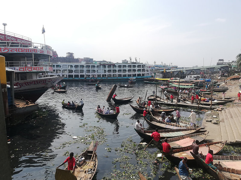
Image courtesy of akhlas rahman on Unsplash
Focusing on middle and low-income cities
This approach gets results, but with such an exhaustive method required, why did WhereIsMyTransport opt to focus on this area? Put simply, the startup saw a gap in the market.
“In most high-income cities, the government manages public transport and provides huge subsidies. But in middle and low-income cities governments simply have fewer resources,” explains de Vries.
“With hundreds or thousands of independent operators, city governments don’t even know what the full map of public transport options looks like.”
“This often means that public transport is ill-equipped to meet people’s needs, particularly when it comes to timely information. With hundreds or thousands of independent operators, city governments don’t even know what the full map of public transport options looks like. So how can they communicate that to residents?
“Informal public transport works wonders despite this opacity. With no subsidy, informal transport moves 80% of the population of most emerging-market cities. The networks also grow organically with the population to keep up with demand.
“So in middle and low-income cities, we see an opportunity to fill this information gap to help billions of people move around more easily.”

Image courtesy of Niloy Biswas on Unsplash
WhereIsMyTransport: Overcoming challenges
This approach involves getting governments to contract the company to map these transport networks, which in and of itself is not always easy.
“Informal public transport operators and city authorities are often at odds, each trying to serve their own interests,” says de Vries.
“But with strong data to back up our arguments, our experience is that coordination can happen.”
The results are also impressive, with de Vries proudly claiming that the company “has the capacity to produce complete and definitive mobility datasets for any emerging-market cities, whatever their size, faster and better than anyone else can”.
“In the cities where we work, we’re the only company that has collected a complete snapshot of informal and formal transport networks for the entire metropolitan area.”
“The major benefit is that we can produce more accurate maps than anyone else. In the cities where we work, we’re the only company that has collected a complete snapshot of informal and formal transport networks for the entire metropolitan area. This includes routes and stop names, operating hours, frequencies and ridership,” he says.
“We are also the first company to add attributes to GTFS (the mobility data standard) for emerging market cities that have only been included, until now, in data sets for the top cities in the developed world.
“For example, in addition to detailed route information, we also map stations and transport hubs – digitising every location (entrances, exits, turnstiles, etc.), pathway and level – so that our data includes detailed maps of the stations themselves, not simply how to get from one to the next.
“The downside of course is that this process is hard. It takes resources, big teams of people, and some real expertise in the subject. But we’ve turned this into our advantage and today we can do megacities of 20 million people in a little over a month.”
Achievements and goals
These aren’t just empty claims. WhereIsMyTransport has already rolled out its efforts in a number of cities, to great effect.
“In November 2019, we mapped the formal and informal public transport networks in Mexico City for one of our major clients. At the time, this was the largest data collection project we had ever completed – a local team of more than 60 working for four weeks to map every route in the metro area; nearly 50,000km of routes,” says de Vries.
“Further client work meant Mexico City was quickly followed by Dhaka [Bangladesh] in January 2020. Dhaka was a much smaller project in terms of team size and number of routes mapped, but we had to cover a much larger area to capture the entire network, which includes buses, rail and river traffic.
“We have developed the world’s foremost playbook (and tool suite) for mapping formal and informal public transport in emerging market cities.”
“Then in February, again for one of our major clients, we mapped Gauteng, the most densely populated province in South Africa. Gauteng is made up of five municipalities, and stretches over an area of 18,162 km² (compared to 1,485 km² for Mexico City). In six weeks, with a local team of more than 100 data collectors, we mapped just shy of 100,000km of routes; by far our largest data collection project to date.”
These ambitious targets achieved, WhereIsMyTransport is now turning its attention to other megacities where the benefits of its offerings can be felt.
“Mexico City, Dhaka and Johannesburg (Gauteng) are three of the Majority World’s most important megacities, with a combined population of 57 million,” he says.
“We have developed the world’s foremost playbook (and tool suite) for mapping formal and informal public transport in emerging market cities, and to put our playbook, our tools, and our team to the test – and to exceed expectations – in these three megacities is a huge achievement.
“The team is now preparing to begin our next three client megacity data collection projects in Latin America and Southeast Asia.”
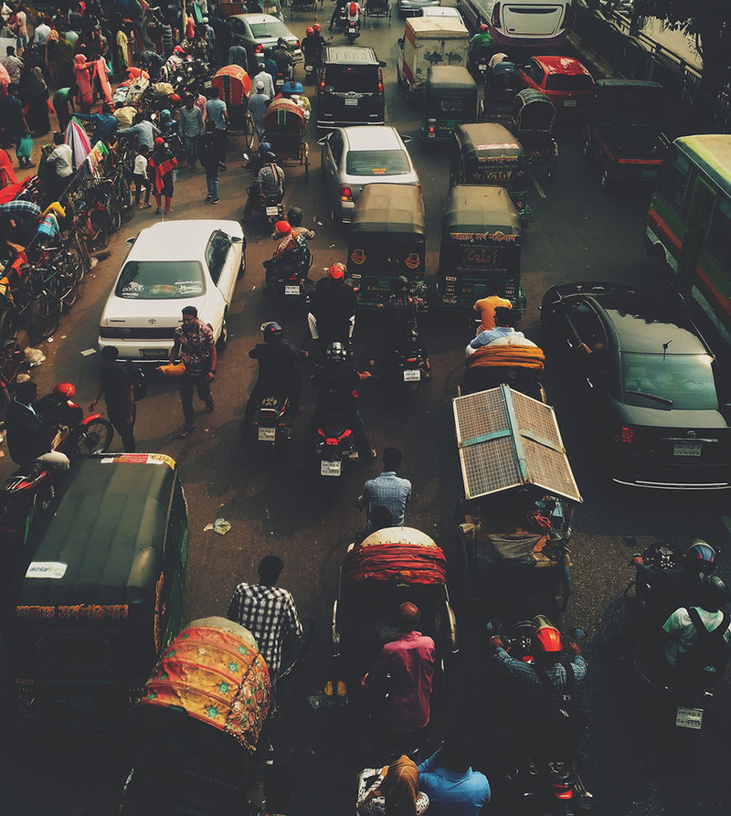
Image courtesy of Niloy Biswas on Unsplash
Looking to the future
Looking further ahead, de Vries has bold ambitions for WhereIsMyTransport.
“We’re expanding WhereIsMyTransport to many more emerging market megacities. Based on the data we’re collecting, we’re building products aimed at helping both commuters and operators,” he says.
“Our goal remains giving billions of people the freedom to move more easily. We believe this is key for social, political and economic growth in emerging markets.”
This essentially translates into small but potentially highly meaningful quality-of-life improvements for billions.
“Our goal is that people who rely on formal and informal transport networks never again find themselves stranded and without information to make the best decision.”
“Ultimately, the biggest benefit is peace of mind. Our goal is that people who rely on formal and informal transport networks never again find themselves stranded and without information to make the best decision. The knowledge of a community will be in their pocket,” he says.
But it also offers a powerfully appealing option for governments.
“We believe receptive governments will incorporate this bottom-up approach into their own transport planning, as it provides an innovative solution at a fraction of the cost of megaprojects,” says de Vries.
“Nobody is better positioned than we are to provide new and innovative mobility solutions for the benefit of citizens and cities in the Majority World.”
Cover video courtesy of Ritam Paul Chowdhury on Pexels
Back to top
Share this article


